All  about  a  would-be  A350  Westbury  BA13  Bypass    
  ... on  the  wrong  side,  routing  the  A350  through  the  wrong  area ...  

... why an eastern bypass ...? ... why does Wiltshire (County) Council want to build a new A350 through the best countryside ...?

Front Page
The Wrong Way
Verdant Valley
Odd Objective
Spiralling Cost
Business Case
No to Funding
Barmy Bypass Bad for BA13
Pollution Risk
Threat to Best of Countryside
Walk the Route
Land Ownership
Cement Works
Wildlife Loss
Why East...?
Choked Town
Ignored Report
West Solutions for Westbury
Our Railway
Parkway
Activity
Failure...
Freightway
Forty Acres
Inquiry Links
Further Links
Web-site...?

Here is a link to www.google.co.uk/maps - the Google map of BA13 Wiltshire.

And, by selection on the Google map, to the satellite view of Westbury (Wilts).

See how the railway junctions, the station, the trading estates and also the A36 (the major road that the A350 eventually joins) are all on the west of Westbury.

A new A350 on the east appears observably barmy.    Is there another agenda?

The eastern A350 bypass scheme did not work as a whole, but became sillier.


Here is a larger simplified diagram of part of the route for an eastern bypass.

There would be a more profound effect upon BA13 than that of a road alone.
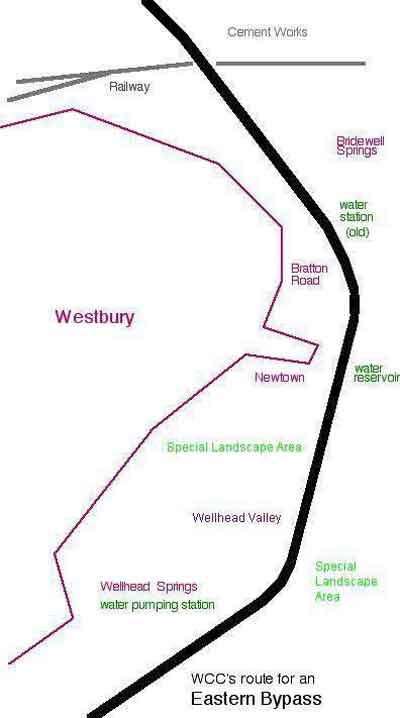
The eastern bypass route is through the middle of the Special Landscape Area.

Think about the substantial strip of presently open land which would be between the route of the eastern bypass and the existing homes on that side of the town.

Local bypasses at Hilperton, Melksham and Chippenham each have housing infill.

Speculative development of new housing based on another bypass at Melksham was being promoted at the National Home Show in 2006 and was in the UK news.

With planning permission, land values can typically increase by up to 100 times.

Preserved space between Swindon and the motorway is now being built over.

The possibility of a redesignation of farm-land for new houses and development as a consequence of the eastern Westbury bypass route is reasonably obvious.
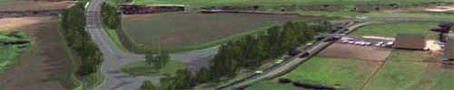
Here is a summary of some of what a local councillor had written:  'My wife and I own 36 acres of land, which we are offering for housing.   There is a roundabout planned on our land as part of the Westbury Bypass.   This would open up clear easy access to the land...'    He was speaking frankly on the fact of the matter.


Here is an unbelievable proposal for Bratton and Edington.   Surely not?


But the eastern bypass route, as actually shown on council planning drawings, really is also right on top of our Westbury Wellhead public drinking water source.

It seems crazy, but happens to be all too true.   It is a Wiltshire Council intention.

The Environment Agency had strongly objected to this.   It seems unbelievable that such a clearly bad route should ever have been chosen in the first place.


next page >>