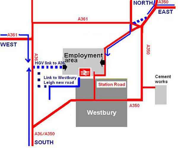
The diagram below shows two link roads: to help at Yarnbrook and to direct lorries into the industrial areas from the west. They would be relatively short sections of new road and, not being part of a strategic route to the coast, would be much cheaper to build, being of a lower specification. The link road from the west could curve, to avoid it going too near to homes. These roads would not be noisy like a major bypass.
Existing residential roads could benefit by having access to the route from the industrial areas to the A36, but would not be used to divert traffic through them.
Communities along the A361, as well as people in Westbury along the present A350 roads etc, would benefit from a new westerly entrance into the industrial area. Many HGV operators, such as from the milk plant, would naturally prefer to go directly to the A36.
Long distance lorries going between the M4 and south coast would be re-directed via the A34, M3 & M27, as recommended by the Bristol/Bath to South Coast Study. It is, in fact, rather better on fuel for lorries to use this route, because there are fewer roundabouts and less gear-changing. The BBSCS consultants recommended that signs should be put up to direct long-distance HGVs by this better way than the A350.
A second stage of the ACA link roads plan would involve a further link to the railway station, so that buses and cars could get there more easily. It would allow Westbury rail station to be upgraded to a parkway, which would be to the benefit of the whole of our part of Wiltshire.
A link road system is also envisaged to relieve the existing tail-backs on the A350 at West Ashton.
We all see halted cars etc waiting as far back as Heywood, with another queue of near-stationary vehicles from Yarnbrook to West Ashton. It is obvious that the Yarnbrook roundabout is inadequate for the vehicles coming onto it from several directions and that the West Ashton crossroads are sufficiently close for them all to be at near to a gridlock at times. Long vehicles are slow in getting past the Yarnbrook roundabout. Few HGVs move at a time, because of the opposing lines of other vehicles. They are slow in pulling away from the traffic-light controlled crossroads at West Ashton also. Hence the congestion between villages. Local link roads could allow vehicles to go past the bottlenecks.
The ACA's diagram of suggested link roads has been kept simple, to best show the fundamental principles.
The diagram is also schematic to avoid planning blight prior to the concept being developed and finalised.
A non-government organisation, such as the ACA, obviously cannot anyway publish detailed route maps.
In 2005, West Wiltshire CPRE submitted a sketch of a suggested link roads concept to the County Council, which the CPRE letter described as an idea, a preliminary study, within various specific objections to the proposed eastern Westbury bypass scheme. But, after it was available for public scrutiny, the concept was persistently misrepresented, by rote, by an irritating small claque of eastern bypass supporters.
It was quite a bitter lesson about not publicly venturing much beyond what are already published details.
The ACA's role is to propose a feasible alternative which would serve the obvious transport and economic needs of the town and surrounding areas, for a fraction of the disproportionate financial and environmental cost of the WC eastern bypass scheme. The ACA publish only a basic idea outlining some of the functions that a link road system could perform - which include reducing overall traffic congestion and pollution.
The blue lines indicate proposed new HGV routes into and out of the major employment area of Westbury.
It is anticipated that these would effectively relieve Westbury's traffic congestion, which is visibly caused by heavy vehicles having to slowly negotiate the many tight corners in the town and coming to a standstill whenever there is anything in the way. HGV operators would benefit from the new direct route system.
The ACA proposals need to be professionally developed by fresh unbiased consultant highways engineers, who would survey and design the link roads, preferably independently of Wiltshire Council.